

What is Cartography? Explore Mapping Techniques & Roles
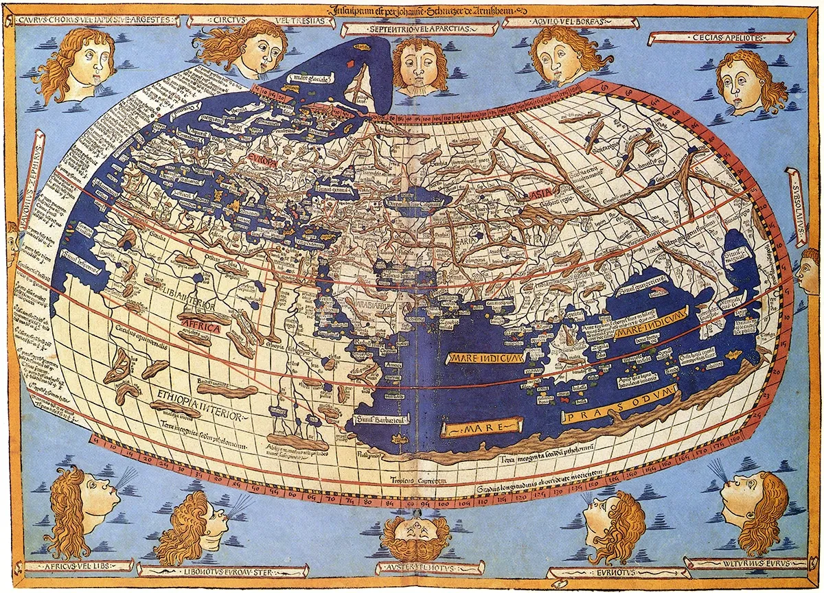
The world map from Leinhart Holle's 1482 edition of Nicolaus Germanus's emendations to Jacobus Angelus's 1406 Latin translation of Maximus Planudes's late-13th century rediscovered Greek manuscripts of Ptolemy's 2nd-century Geography. (Decorative Maps by Roderick Barron)
Introduction to Cartography
Cartography stands at the crossroads of art and science, embodying the craft of map-making and utilization. This discipline is pivotal to human advancement, encapsulating the creation, production, and analysis of maps. Maps are essentially graphical depictions of geographical spaces, rendered typically on flat surfaces. The essence of cartography lies in its ability to blend scientific principles, aesthetic appeal, and technical skills to mirror reality, thereby facilitating the effective conveyance of spatial data.
From navigating through unknown territories, comprehending spatial relationships, to geographic data examination, cartography is indispensable. Its historical roots stretch back to antiquity, with the oldest known globe by Martin Behaim in 1492, highlighting a significant leap in cartographic development. Through time, cartographers have refined their craft, transitioning from traditional tools to sophisticated technologies like Geographic Information Systems (GIS) and remote sensing, thus elevating map-making's precision, efficiency, and intricacy.
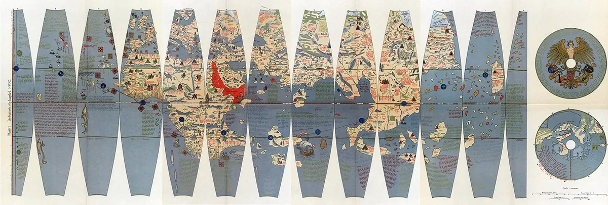
Ernst Ravenstein: Martin Behaim. His Life and his Globe.
Cartography's significance extends beyond mere navigation and land surveying to thematic mapping, serving as a critical tool in political, economic, and social discourse. During the Age of Exploration, enhanced cartographic methods bolstered trade, colonization, and cultural exchanges by offering more accurate world views. Presently, cartography remains a fundamental aspect of geographic science, supporting urban planning, environmental stewardship, and various other domains.
Core Techniques in Cartography
Map Projections
One of the fundamental techniques in cartography is the use of map projections. A map projection is a method of transforming the curved surface of the Earth onto a flat plane. This process is essential because it allows cartographers to create two-dimensional maps from the three-dimensional surface of the Earth.
However, all map projections introduce some level of distortion, whether in terms of shape, area, distance, or direction.
There are various types of map projections, each designed to preserve different properties of the Earth's surface. For example, conformal projections, such as the Mercator projection, preserve angles and shapes well, making them ideal for navigation.
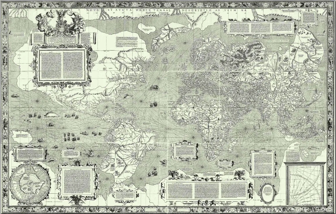
Carta do Mundo de Mercator (1569)
However, they distort areas, particularly near the poles. Equal-area projections, like the Albers conic and Mollweide projections, maintain the relative sizes of features but often distort shapes and angles.
Compromise projections, such as the Robinson projection, balance between these distortions to create visually appealing and relatively accurate world maps.
Symbolization and Scale
Symbolization is another critical aspect of cartography, involving the use of symbols, colors, and other visual elements to represent geographic features on a map. Cartographers must carefully select these symbols to ensure they are clear, consistent, and meaningful to the map's users.
For instance, points, lines, and polygons are used to represent different types of features, such as cities, roads, and boundaries. The choice of symbolization can significantly impact the map's readability and the effectiveness of the information it conveys.
The scale of a map is also a vital consideration. Map scale determines the level of detail and the extent of the area covered by the map.
Cartographers use different scales for various purposes; for example, large-scale maps are detailed and cover smaller areas, while small-scale maps are less detailed but cover larger areas. The scale affects not only the level of detail but also the generalization and symbolization used on the map.
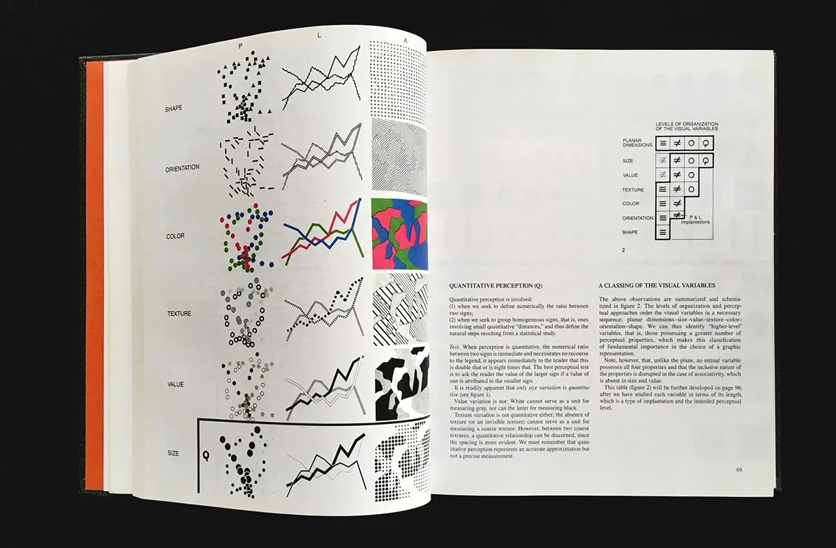
Jacques Bertin: Semiology of Graphics (source: https://flexiblevisualsystems.info/resources/semiology-of-graphics/)
Generalization and Accuracy
Generalization is the process of simplifying and abstracting spatial information to make it suitable for representation on a map. This technique is essential when creating maps at different scales, as it ensures that the most important features are emphasized while less critical details are omitted or simplified.
Cartographic generalization involves methods such as simplification, combination, displacement, and exaggeration to maintain clarity and readability on the map. This process is both an art and a science, requiring cartographers to balance the need for detail with the need for simplicity and clarity.
Accuracy is a paramount concern in cartography. Cartographers use various techniques to ensure that maps are as accurate as possible. This includes the use of Geographic Information Systems (GIS), remote sensing, and photogrammetry to gather and process geographic data.
Modern cartography also leverages advanced software tools and algorithms to automate many of the generalization and mapping processes, enhancing both the speed and accuracy of map production.
The Role of Modern Cartographers
Technology and Innovation
Modern cartographers lead the charge in the evolution of mapping and navigation, thanks to the integration of Geographic Information Systems (GIS), remote sensing, and photogrammetry. This blend of technologies has transformed the field, allowing for the creation of maps with unparalleled accuracy and detail. Artificial Intelligence (AI) and machine learning are now pivotal in processing sensor data, streamlining the production and updating of digital maps.
For example, technologies such as HERE's UniMap can identify map features in both 2D and 3D, merging them with previous map versions to produce new digital maps in as little as 24 hours.
Moreover, by utilizing advanced software and proprietary streaming perception stacks, modern cartographers can gather and analyze real-time data from various sources. This includes the use of onboard sensors to detect road features, generate self-updating live HD maps, and provide precise lane-level information, speed data, and up-to-the-minute insights on traffic and weather conditions. These advancements significantly boost the efficiency and capability of cartographers in map production and maintenance, particularly for autonomous driving and real-time navigation applications.
Educational Outreach and Policy Advocacy
Contemporary cartographers are also pivotal in educational outreach and policy advocacy. Through participatory mapping, they enable communities to share their spatial knowledge and insights.
This collaborative method ensures that maps accurately reflect the realities and priorities at the community level. Community mapping teams, for instance, can utilize mobile mapping apps like MapSwipe or OpenMapKit to gather real-time data, which is then verified and used in advocacy efforts.
In the realm of policy advocacy, cartographers wield maps as influential tools to sway decision-makers. By employing clear visualization techniques, such as story maps and data overlays, they can underscore critical issues and illustrate changes over time.
This strategy converts complex data into persuasive visual narratives that can foster policy shifts and advance social justice efforts. Cartographers also monitor policy implementation through regular map updates, tracking progress and evaluating the impact to document successes.
Specialized Fields and Applications
Today's cartographers operate across a diverse array of specialized fields, each demanding distinct skills and applications. For example, in urban planning and environmental management, they employ GIS to analyze and display spatial data, aiding in the creation of sustainable urban designs and conservation plans. In disaster response, they produce essential maps that support emergency preparedness, response, and recovery activities.
They also engage in thematic cartography, crafting maps focused on specific topics like climate change, population density, and economic trends. These thematic maps serve critical roles for academic, political, and business entities, offering insights that influence policy and strategic decisions.
Additionally, modern cartographers play a key role in developing digital maps for educational content, tourist guides, and nautical navigation, ensuring their contributions are valuable across a broad spectrum of sectors.
Conclusion
In summary, cartography is an intricate discipline that merges the realms of art, science, and technology to forge maps that are not only meaningful but also precise. At the heart of crafting these maps lies the essential steps of identifying their purpose and significance, selecting the correct scale and projection, and meticulously abstracting and generalizing information. Today's cartographers utilize cutting-edge tools such as Geographic Information Systems (GIS), remote sensing, and photogrammetry to elevate their creations.
It's important to note that successful cartography is rooted in deliberate design choices including symbolization, color palettes, typography, and the organization of visual elements. By honing these skills, cartographers can deliver maps that are both aesthetically pleasing and rich in information, serving as invaluable tools for inspiration, education, and navigation. As you delve into the expansive field of cartography, think about how you can embrace these principles to craft maps that not only inform but also captivate and guide your audience.
FAQ
What is the simple definition of cartography?
Cartography is both an art and a science focused on the creation and application of maps. It encompasses geography, design, and technology to illustrate spatial relationships and convey geographic information effectively.
What does cartography study?
Cartography involves the study of map making, including the analysis and interpretation of maps to visually represent geographic information. It is a field that merges science, aesthetics, and technique to accurately model reality and share spatial information, incorporating the collection, interpretation, and visualization of physical and geographic data.
What is an example of cartography?
One common example of cartography is the production of topographic maps. These maps detail the Earth's surface, showing natural and man-made features such as elevation, terrain, roads, rivers, and landmarks through the use of contour lines and symbols.
What is the main purpose of a cartographer?
The primary goal of a cartographer is to gather, analyze, and present geographic data through detailed and precise maps. These maps serve a variety of purposes, including urban planning, environmental monitoring, educational use, and more, aiding individuals, organizations, and governments in understanding and navigating different geographical areas.
About Woosmap
Woosmap empowers businesses to optimize Location Services and Intelligence with precision and efficiency. By leveraging advanced geolocation, Store Locator, and Map API tools, Woosmap ensures accurate deliveries, streamlines address entry processes, and enhances customer satisfaction. With a strong commitment to privacy, Woosmap delivers innovative, GDPR-compliant solutions that do not collect personal data, making it a trusted partner for companies prioritizing both performance and user trust.