Map of Spain
Introduction: Understanding Spain Through Its Geography
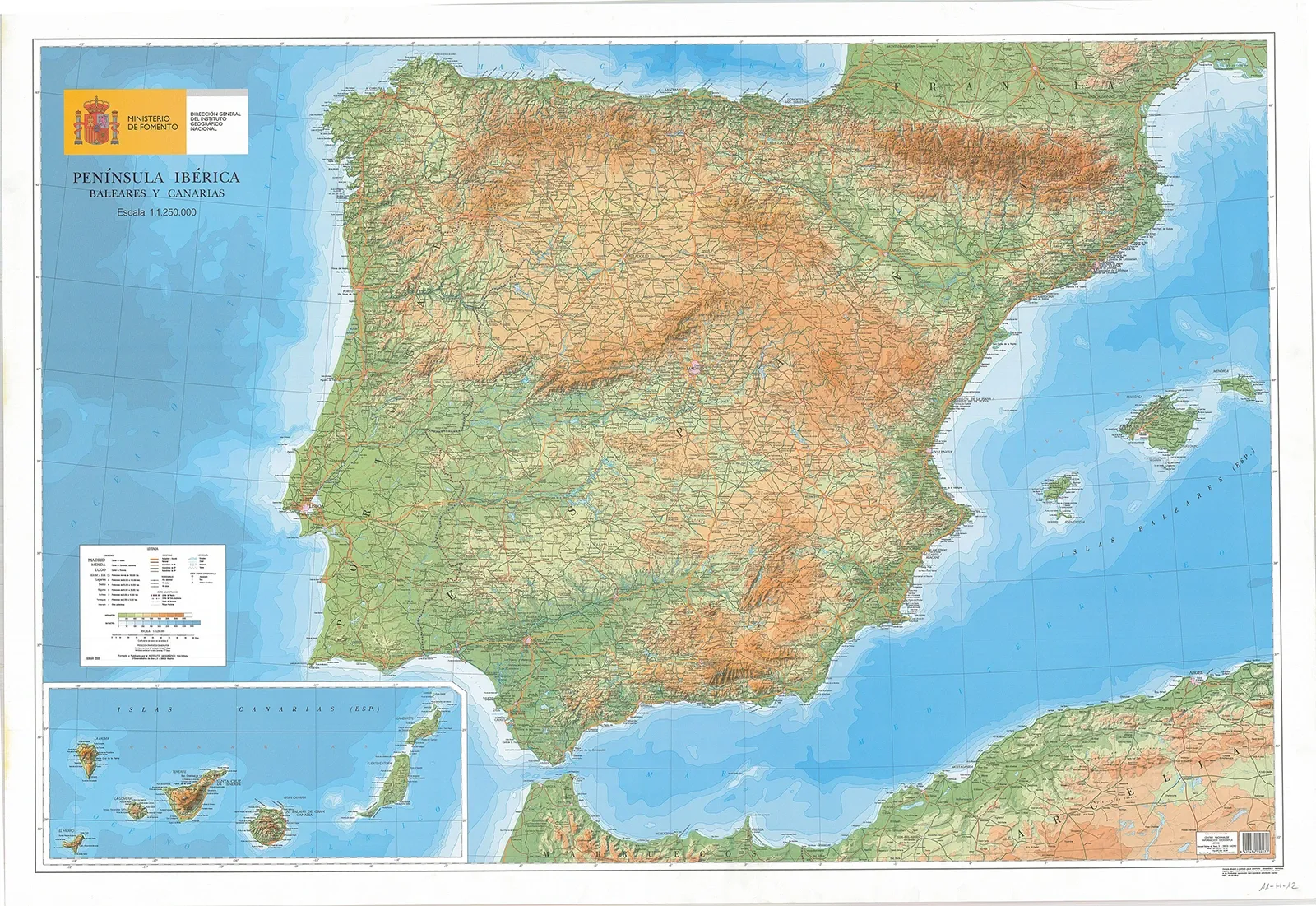
Spain conjures images of vibrant cities, a rich cultural heritage, and breathtaking landscapes, but to fully grasp its essence, one must begin with its geography. Nestled in southwestern Europe on the Iberian Peninsula, Spain is bordered by Portugal, France, Andorra, and Morocco, the latter across the Strait of Gibraltar. The country's diverse terrain is marked by the presence of the Balearic Islands in the Mediterranean Sea and the Canary Islands in the Atlantic Ocean, near Africa.
This geographical diversity shapes Spain's varied climates and regional characteristics. The northern Pyrenees Mountains and the Meseta Central, a sprawling plateau at the country's heart, showcase the range of Spain's landscapes. Its eastern and northern coasts are caressed by the Mediterranean Sea and the Atlantic Ocean, including the Bay of Biscay, influencing the regions' elevation, climate, and way of life.
Exploring Spain's geography reveals more than just its physical boundaries; it offers insight into a nation steeped in history, culture, and natural splendor. Each area, from the autonomous communities to the distinct regions, contributes to Spain's rich and diverse identity, inviting a deeper understanding and appreciation of this unique country.

Political Map of Spain: Regions and Provinces
The Autonomous Communities
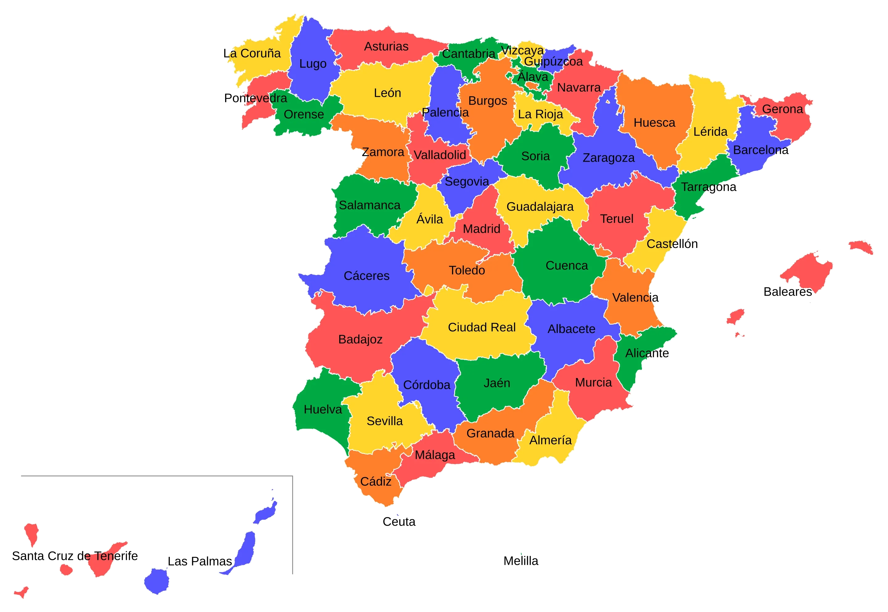
Spain is divided into 17 autonomous communities, each boasting its own distinct identity and autonomy level.
These communities were formed under the Spanish Constitution of 1978 to grant limited autonomy to Spain's various nationalities and regions. Each autonomous community possesses its own government, institutions, and symbols, governed by their respective Statutes of Autonomy. These statutes outline the powers and responsibilities unique to each community, which can vary widely.
Communities such as Catalonia, the Basque Country, and Galicia, recognized as "historic nationalities," enjoy broader powers than others.
The autonomous communities are further divided into provinces, totaling 50 across Spain. Each province features its own governmental institutions and consists of numerous municipalities.
This hierarchical structure facilitates a decentralized governance system, empowering regional and local governments to manage their affairs independently, including urban planning, public works, environmental protection, and cultural affairs.

Major Cities and Capitals
Each autonomous community in Spain has a capital city, typically serving as the region's administrative and cultural center. For instance, Seville is the capital of Andalusia, Barcelona of Catalonia, and Madrid serves as both the Community of Madrid's capital and the capital of Spain. Other notable cities include Valencia in the Valencian Community, Malaga in Andalusia, and Santiago de Compostela in Galicia.
These cities are pivotal administrative centers and dynamic cultural and economic hubs, enriching the diverse fabric of Spanish society.
Beyond their capitals, many autonomous communities feature other significant cities contributing to their regional economies and cultural landscapes. The Basque Country, for example, is home to Bilbao and San Sebastián, while the Canary Islands boast Santa Cruz de Tenerife and Las Palmas as their capitals.
These cities showcase the varied historical, cultural, and economic backgrounds of their regions, highlighting Spain's complex and multifaceted identity.
Physical Map of Spain: Natural Landscape and Climate
Mountain Ranges and Rivers
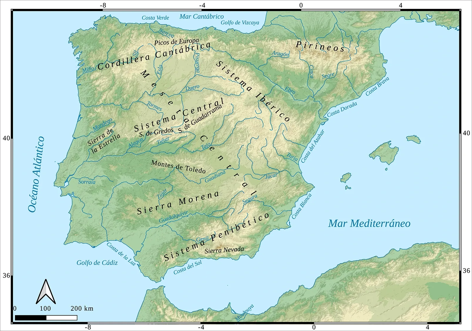
Spain's physical landscape is characterized by its diverse and rugged terrain, with several prominent mountain ranges that shape the country's geography. The Pyrenees mountain range, located in the north, serves as a natural border between Spain and France, and it is one of the most notable mountain chains in the country. This range extends for approximately 435 kilometers from the Mediterranean to the Bay of Biscay and includes peaks such as those in the Picos de Europa, which surpass 2,500 meters in height.
In the central part of Spain, the Sistema Central mountain range divides the Meseta Central into two smaller plateaus. This range includes mountains like the Sierra de Guadarrama and the Sierra de Gredos, which are significant for their ecological and recreational importance. Other major mountain ranges include the Cordillera Cantábrica in the north, the Sistema Ibérico in the northeast, and the Penibético range in the southeast, which features the Sierra Nevada and its highest peak, Mulhacén, at 3,482 meters above sea level.
Spain's river system is also an important aspect of its physical landscape. Major rivers such as the Tagus, Duero, Ebro, and Guadalquivir play vital roles in irrigation, transportation, and supporting agricultural activities. The Guadalquivir River, for instance, flows through the Andalusian Plain, making it a fertile and agriculturally rich region. The Ebro River, originating from the Ibérico region, is another significant waterway that supports the Ebro Basin in northeastern Spain.

Climate Zones
Spain's climate is as diverse as its geography, with various climate zones influenced by its location on the Iberian Peninsula and its island territories. The country can be broadly divided into several climate zones. The Mediterranean climate, prevalent along the eastern and southern coasts, is characterized by hot, dry summers and mild, rainy winters. This climate supports the growth of Mediterranean forests and scrublands, particularly in regions like the Andalusian Plain and the coastal areas of Valencia and Catalonia.
In contrast, the northern regions of Spain, such as Galicia and the Basque Country, experience a more Atlantic climate, with cooler temperatures and higher rainfall throughout the year. The Cantabrian Mountains act as a climatic barrier, ensuring that these northern areas receive significant rainfall, contributing to the lush vegetation and green landscapes known as "Green Spain".
The interior of Spain, including the Meseta Central, has a continental climate with hot summers and cold winters. This region experiences significant temperature variations between seasons, making it distinct from the more temperate coastal areas. The Canary Islands, located off the northwest coast of Africa, have a subtropical climate, with Mount Teide on Tenerife being a notable example of a region with a unique microclimate due to its high elevation.
Cultural Map of Spain: Languages and Heritage
Spain's Linguistic Diversity
Spain is a country renowned for its rich linguistic diversity, reflecting the varied cultural and historical backgrounds of its regions.
Beyond the official language, Spanish (Castilian), there are several other languages that are integral to the country's cultural tapestry. Catalan, spoken by over 7 million people, is an official language in Catalonia, Valencia, and the Balearic Islands. It is deeply embedded in the local culture, with street signs, education, and public services often conducted in Catalan alongside Spanish.
Galician, spoken by approximately 3 million people, is the official language of the Galician region in northwestern Spain. It shares close ties with Portuguese and is a key part of Galician identity, with efforts to promote and preserve the language through education and cultural events.
The Basque Country is home to Euskara (Basque), a language unique in that it has no known linguistic relatives. It is one of the oldest languages in Europe and is spoken by over 1 million residents. Euskara has a standardized form, Euskara Batua, which is used in formal situations such as education, literature, and media.
In addition to these languages, Spain also recognizes other regional languages, including Aranese in Val d’Aran, Asturian in Asturias, and Occitan in the Pyrenees. These languages, though less widely spoken, contribute significantly to the cultural richness and diversity of their respective regions.
UNESCO World Heritage Sites
Spain's cultural heritage is not only reflected in its languages but also in its numerous UNESCO World Heritage Sites.
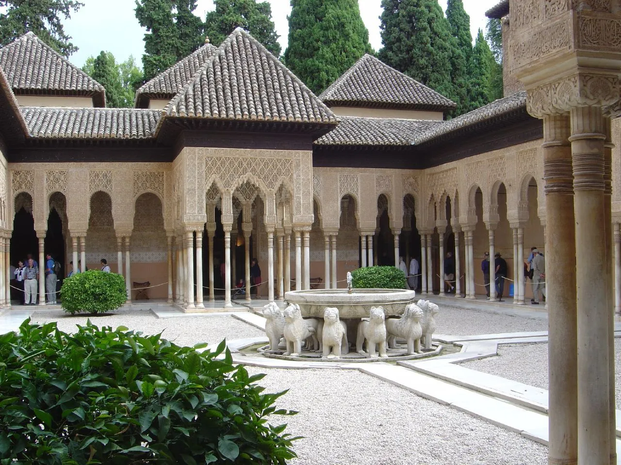
These sites are a testament to the country's historical and cultural significance. The Alhambra in Granada, a masterpiece of Islamic architecture, is one of the most famous World Heritage Sites in Spain. This palace and fortress complex showcases the Moorish influence on Spanish culture and architecture.

The city of Barcelona is home to several World Heritage Sites, including the works of Antoni Gaudí, such as the Sagrada Família, Park Güell, and Casa Milà. These iconic structures are symbols of Catalan Modernism and have become synonymous with Spanish cultural innovation.
The historic city of Toledo, with its blend of Moorish, Gothic, and Renaissance architecture, is another significant World Heritage Site. This city has been a melting pot of different cultures, including Christians, Muslims, and Jews, and its architecture and cultural festivals reflect this rich history.
Spain's cultural map is also marked by its festivals and traditions, many of which are tied to its UNESCO World Heritage Sites. For example, the Tomatina festival in Buñol, Valencia, and the Semana Santa (Holy Week) processions across various cities are vibrant expressions of Spanish culture and community spirit. These events, along with the country's linguistic diversity, make Spain a unique and fascinating cultural destination.
Conclusion: The Geographical Tapestry of Spain
Spain's geography is a rich and intricate tapestry, woven from diverse landscapes, climates, and cultural heritage. From the Pyrenees mountain range to the Meseta Central, and from the Mediterranean coast to the Atlantic islands, each region contributes uniquely to the country's identity. The linguistic diversity, with languages like Spanish, Catalan, Galician, and Basque, adds depth to its cultural map.
With numerous UNESCO World Heritage Sites and a biodiversity that ranks among the highest in Europe, Spain is a treasure trove of natural and cultural wonders. As you explore this fascinating country, remember its complex geography, vibrant cultures, and the importance of preserving its natural and cultural heritage for future generations.
FAQ
What are the main geographical features of Spain?
The main geographical features of Spain encompass the Meseta Central, a high inland plateau bisected by the Sistema Central mountains; the Pyrenees in the northeast; the Cantabrian Mountains to the north; the Sierra Morena and Sistema Ibérico in the south and east; along with lowland areas like the Andalusian Plain and the Ebro Basin. Spain's varied coastline stretches along the Atlantic Ocean and the Mediterranean Sea, incorporating the Balearic and Canary Islands.
How many autonomous communities does Spain have, and what are their unique characteristics?
Spain is divided into 17 autonomous communities and two autonomous cities, Ceuta and Melilla, each with distinct cultural, historical, and linguistic traits.
For instance, Andalusia is celebrated for its Flamenco music and dance, as well as historical landmarks such as the Alhambra. Catalonia boasts a strong sense of nationalism alongside the Catalan language, while Galicia is noted for its Celtic heritage and the Galician language.
What are the major bordering countries and bodies of water surrounding Spain?
Spain shares its borders with Portugal to the west, France and Andorra to the northeast, and Gibraltar to the south, along with Morocco through the autonomous cities of Ceuta and Melilla. It is flanked by the Mediterranean Sea to the east and southeast, the Atlantic Ocean to the northwest and southwest, and the Bay of Biscay to the north.
What is the climate like in different regions of Spain throughout the year?
Spain's climate varies widely across its regions:
- Hot-summer Mediterranean (Csa): Characterized by hot, dry summers and mild winters, this climate is typical of the Mediterranean coast, Andalusia, and Extremadura, with most rainfall occurring in autumn.
- Warm-summer Mediterranean (Csb): Featuring cooler summers, this climate is prevalent in Galicia and central-northern Spain, with wet winters and dry summers.
- Semi-arid (BSk): Marked by extremely hot summers and minimal rainfall, this climate is found in southeastern Spain, including Almería, Murcia, and Alicante.
- Oceanic (Cfb): Known for mild temperatures, high humidity, and frequent rainfall, this climate is typical in the north, including Galicia, Basque Country, and Asturias.
- Tropical: The Canary Islands enjoy a stable climate year-round.
About Woosmap
Woosmap provides powerful location solutions that help businesses connect with users on a local level, all with a privacy-first approach. The Woosmap Map API offers high-performance, customizable maps that make geolocation easy and accurate.
Here, Woosmap brings an interactive map to geographic insights about countries, delivering a seamless way to explore places like Italy.
Spain
Administration
Form of Government: Parliamentary constitutional monarchy
Official Language: Spanish (primary)
Capital: Madrid
Geographical Coordinates: 40.4168° N, 3.7038° W
Currency: Euro (EUR)
Currency Symbol: €
National Holidays:
- Constitution Day (Día de la Constitución): December 6
- National Day (Fiesta Nacional de España): October 12
- Epiphany (Día de Reyes): January 6
Geography
Three Largest Cities:
- Madrid: Population ~3.3 million, the political, cultural, and economic center of Spain.
- Barcelona: Population ~1.6 million, renowned for its architecture, arts, and Mediterranean lifestyle.
- Valencia: Population ~800,000, a hub for trade, festivals, and coastal beauty.
Total Area: 505,990 km²
Global Size Ranking: ~51st largest country in the world by land area
Water Area: Includes major rivers such as the Ebro, Guadalquivir, and Tagus, along with coastline along the Atlantic Ocean and Mediterranean Sea.
Time Zones
Standard: Central European Time (UTC+1)
Daylight Saving: Central European Summer Time (UTC+2)
Demography
Total Population: Approximately 47 million
Population Density: About 93 people per km², with higher densities in urban regions like Madrid and Barcelona.