

Indoor Navigation: A Complete Guide by Woosmap
Indoor navigation is transforming customers’ journey in indoor environments like malls, events, museums… and can also influence everyday life in airports, train stations or even in hospitals.
In this guide, we delve into the key technical elements of indoor navigation such as indoor mapping, user positioning, distance calculations and guidance. Then, we explore some of the multitudes of use cases that could be implemented with indoor navigation to give you an idea of what can be created for mobile apps and applications with this technology!
What is indoor navigation?
Indoor navigation is the use of technologies and systems that help users, visitors or professionals, navigating and finding their way within indoor environments (malls, airports, resorts, parks or any other large facilities). Creating a complete and efficient indoor navigation experience needs four key elements.
Indoor Mapping
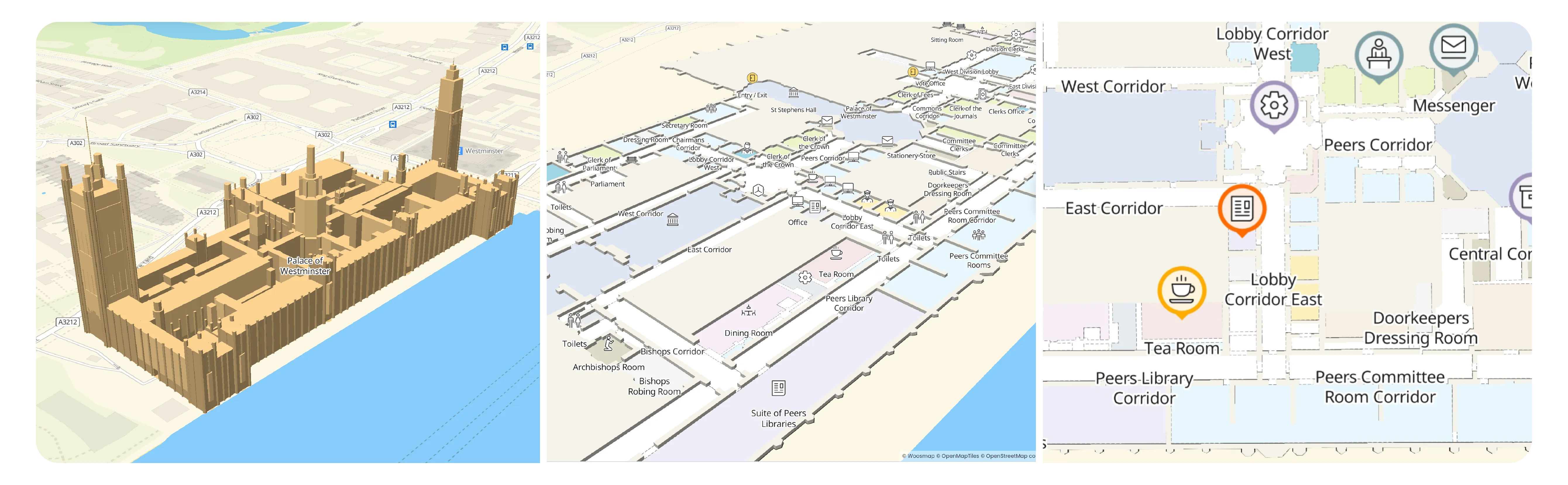
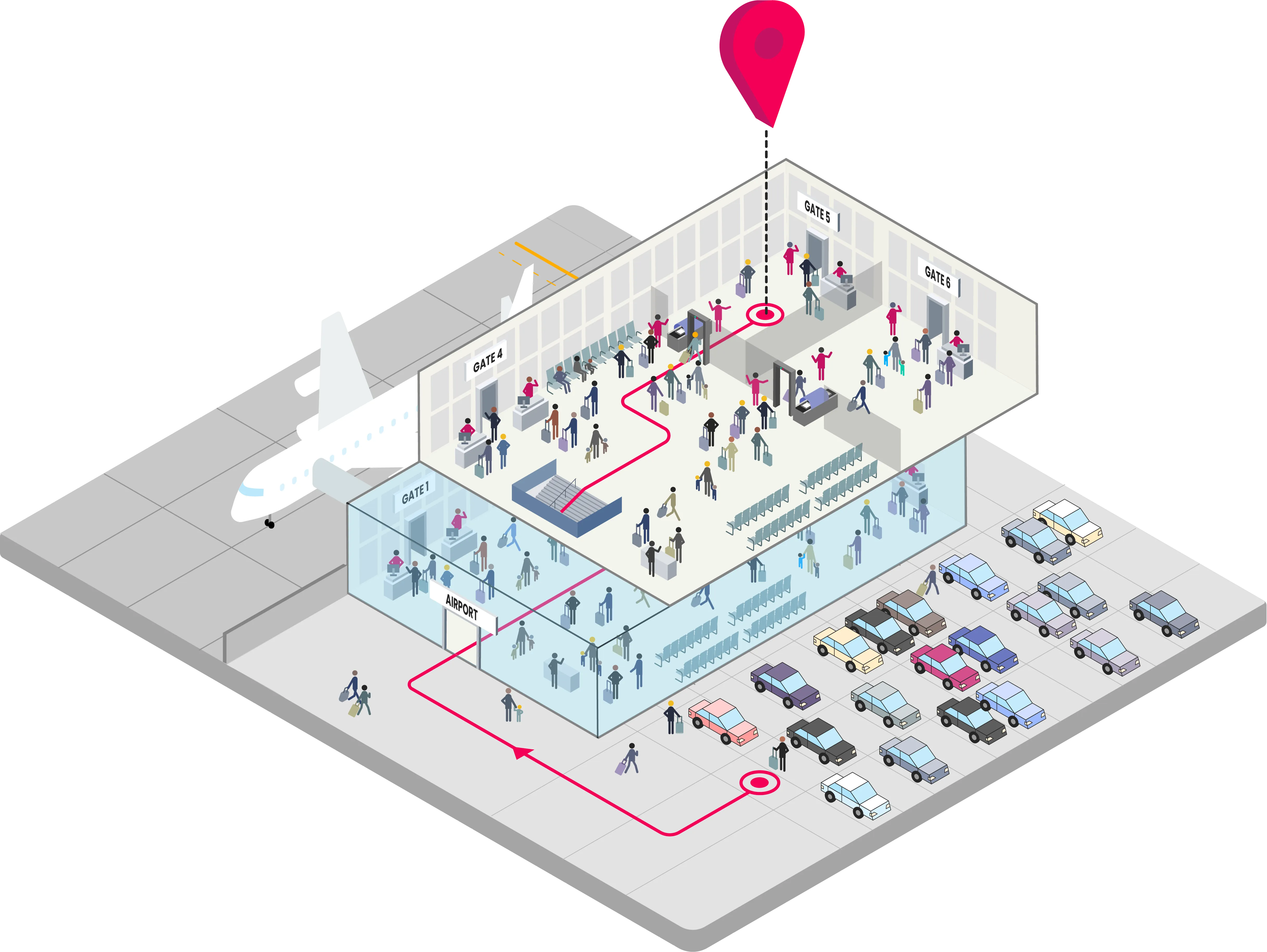
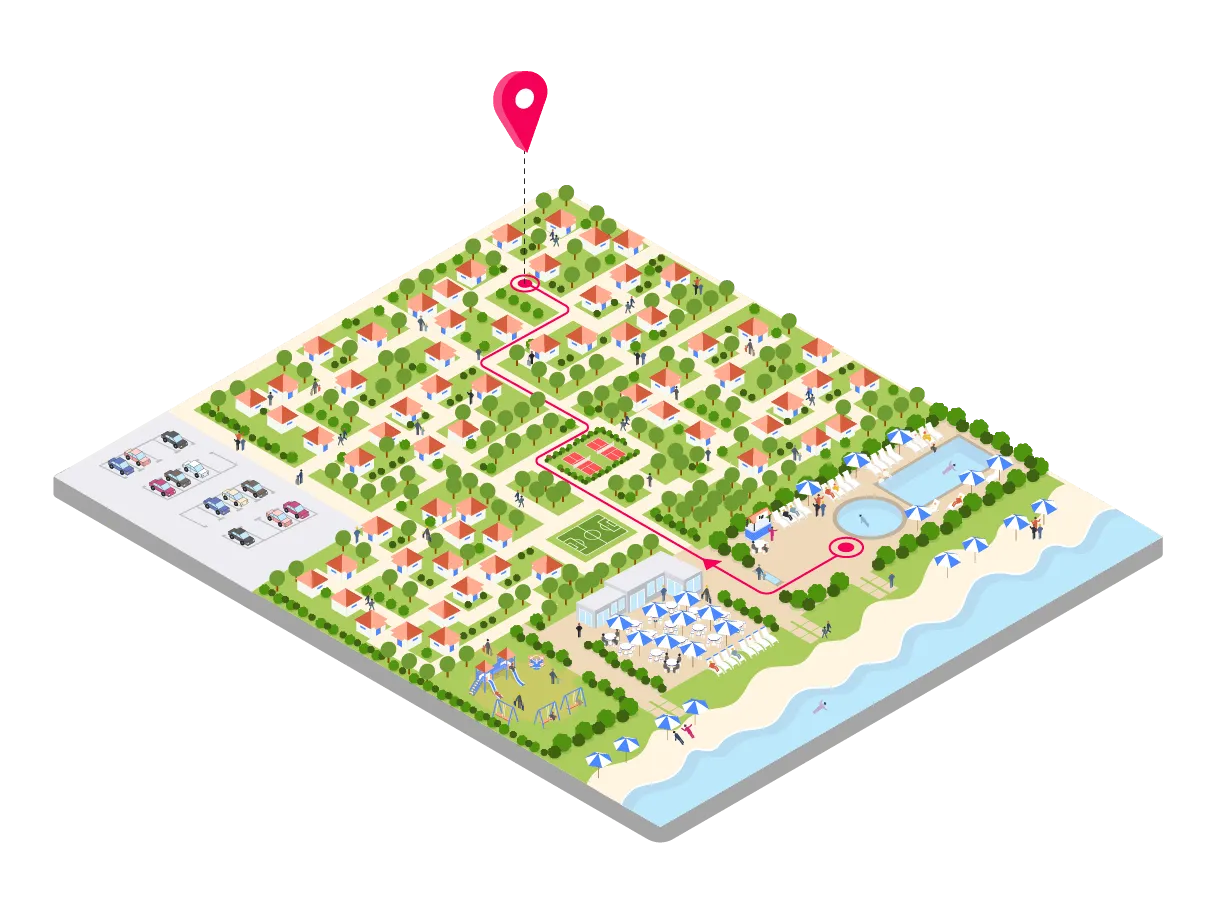
This first element needed is contextual: the indoor map. An indoor map is a detailed floor plan of every floor, locations, paths that can be taken by visitors, and any other points of interest that we can find in the indoor / private space. The map can be shown on a platform or a mobile application (Android or iOS).
On this map, users can zoom in and out on every location, zone, look at the floors in detail and click on precise point of interest like shops to get more information. According to integration (widget or fully custom), the indoor map is usually displayed and combined with a side panel. Thus, upon clicking on a location, this side panel displays a description of the place, the opening hours, photos, contact information etc
Prior to everything else and after the map digitalisation, a navigation network has to be determined on the map: where people can walk and can’t, where are the lifts, the stairs, the accessible path for different mobilities etc. Different paths for different profiles can also be determined here. For example, for people with reduced mobility or security agents with special accesses, etc. will need appropriate guidance to other users. This bit is crucial as the quality of the network will influence the quality of the navigation.
User’s blue dot
The second element needed for an indoor navigation experience is the user position (or blue dot). This is the first information required when starting the navigation (when live).
Being precise on the indoor position of a user will determine the rest of the experience. The user’s position can be obtained thanks to different technologies (GPS, IPS, Bluetooth, WiFi) that we’ll describe later on in this guide.
Distance Calculation
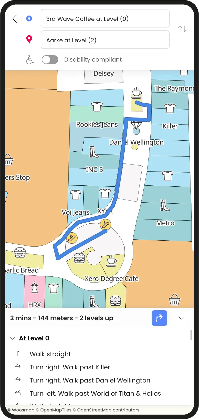
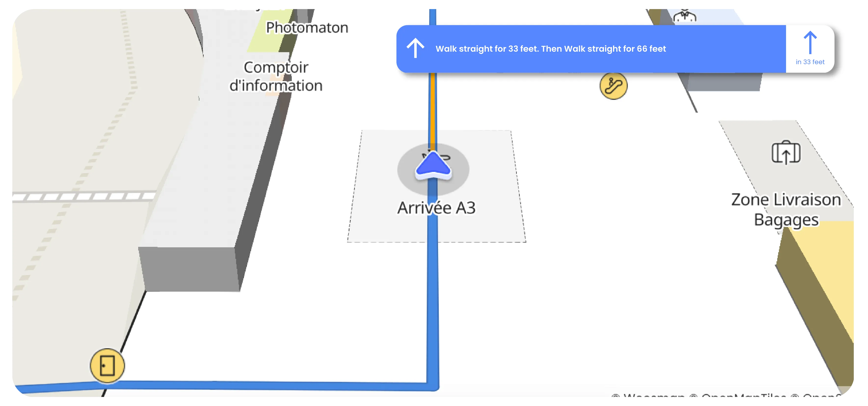
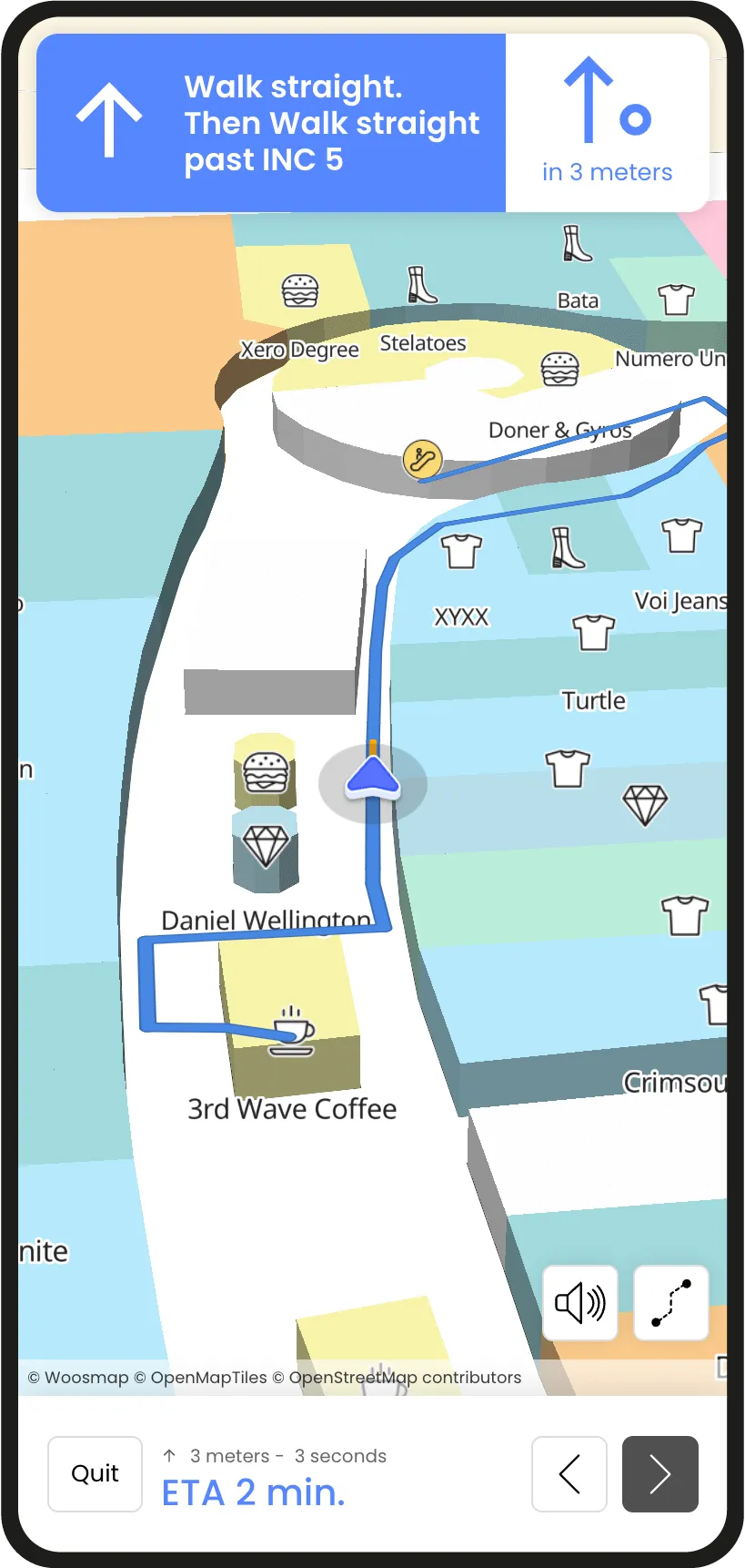
Thanks to a defined navigation network on the indoor map, a distance calculation can be done between two points indoors (usually the user’s indoor location and his destination). The calculation is usually represented by a blue path on the map accompanied by the estimated distance (in meters) as well as the estimated time of arrival (in minutes).
It’s quite similar to the outdoor GPS navigation we use when taking the car. Once the “start button” is pressed, we move on to the guidance.
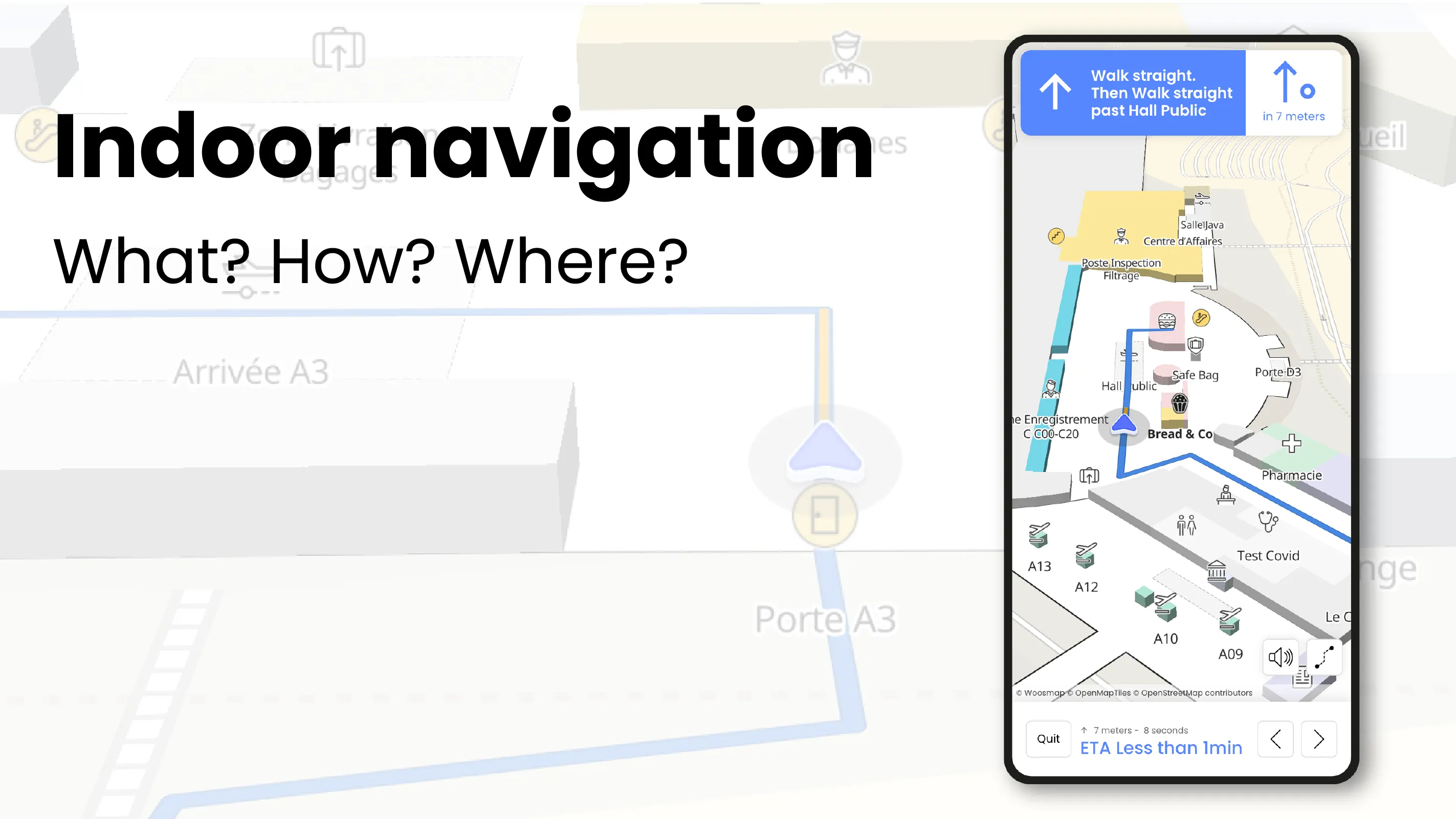
Guidance
The indoor navigation experience starts when the user is guided step by step until arrival to the destination. The navigation will stand out from distance calculation, where we see the path to take in its entirety, with the screen putting the user in the center and following them along the way.
The best navigation systems are the ones giving a lot of contextual information in real-time, staying close to the user and giving the best visual representations. This part is also similar to the one we have when we travel by car using GPS. Spoken instructions can also be turned on.
The differentiator
The navigation instructions can be either classic, following orientation (“turn left”, “turn right”, “go straight for 20 meters”...), or they can be contextualised.
Contextualised instructions are cues that take the environment into account. As a result, we have instructions that look (and sound) more like "At the Burger King, turn right." This is the approach chosen at Woosmap because it provides a more easy and natural navigation experience.
We also noticed some patterns in user’s behaviour: when using the app, users like to switch several times between navigation mode and the view of the entire route to check where they are. When providing any services like this one, it is crucial to provide a smooth experience when switching from one to the other!
How Does an Indoor Navigation System Work?
Indoor navigation is a combination of technologies assembled to create a new experience for mobile users. We will see below which technologies are used and what for.
Position sharing is the key trigger
From the moment the user shares his position, and we can technologically retrieve it, the app follows the user and display automatically the directions according to the path and their progression.
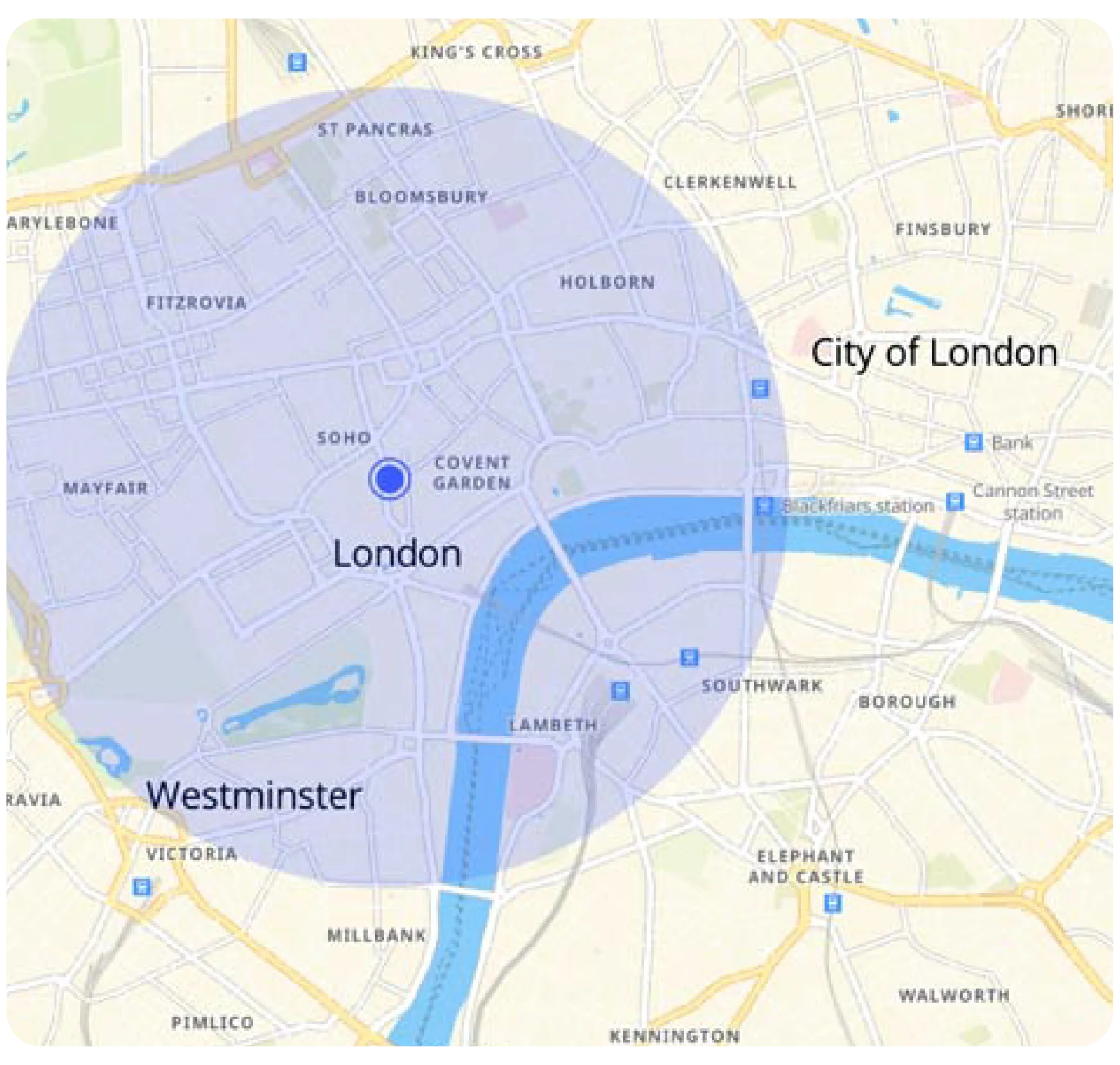
Indoors, we can use a GPS (the same used for outdoor navigation) to track users. The problem with only using GPS is that signals can be obstructed by buildings and be less accurate. For indoor experiences, having a five to ten meters difference in the user’s position can make a big difference on the path. It’s crucial to be the most accurate when tracking a device, to provide the best route and contextualised instructions.
Moreover, GPS is only giving us a two dimension data (latitude, longitude) and for buildings with several floors, this is an important limitation to indoor navigation. Indeed, no way with GPS only to guide a user among a venue with several levels.
Offline navigation
We need to precise that if the user doesn’t wish to share their position, or if they are not in the indoor space, they will still access the navigation experience, but not live. They’ll have to manually share a point A and a point B for the path calculation. Then, they’ll access the navigation step by step and be able to manually move from one step to the next.
This can be useful for users preparing a trip and having to go through big airports. It allows users to check their route in advance, to see where they should go and familiarise themselves with the premises.
IPS
To overcome GPS limitation when it comes to user’s location we recommend to use an Indoor Positioning System (IPS), a technology used for mapping and navigating indoor spaces with precision. This allows for close tracking and, if necessary, recalculating the route if they deviate from it (similar to what is encountered during car navigation). It gives a real 3D indoor experience.
Go further in precision
The indoor positioning system can rely on several technologies to determine the user’s location and follow it. These technologies will also be useful for multi-floors navigation, a missing dimension with GPS.
Let’s start with beacon technology. Beacons, usually using BLE (Bluetooth Low Energy) are little boxes to physically put around the place. Those boxes emit low signals that will be picked up by phone. Mobiles, with dedicated IPS SDK, then compute precise information on their location based on triangulation calculations and power of beacon signals.
On the same principle, WiFi hotspots can also be used to recreate the user’s location (often met in malls, airports or train stations).
Other IPS solutions use geomagnetic fields to define locations inside a venue. A first fingerprinting phase allows to measure magnetic field variations in all the venue. This fingerprint is then used by dedicated IPS SDK to locate a user based on magnetic fields around.
Eventually, some IPS solutions combine parts or all those technologies to provide the best accurate indoor location.
For smaller budgets
Implementing an IPS technology can be too costly for small businesses looking to implement this new service, that’s why other simpler solutions were developed at lesser costs.
For example, unique QR codes can be placed around the buildings at precise locations, and when scanned QR code defines where the user is and can provide a departure point for a navigation path.
Another example on the tech side, for companies that don’t have the want to undertake a complex coding project, you can buy premade packs - widgets - that you can personalise to go quickly about the project.
Indoor Navigation Use Cases
Indoor navigation technology offers a wide range of applications in every sectors, enhancing user experiences in diverse environments. Below, we talk about some key use cases where indoor navigation plays an important role in optimising the user’s experience.
Retail Environments
Indoor navigation in shopping centres, malls, outlets, or markets gives visitors access to explore and wander in these big complexes easily and efficiently. It offers detailed guidance to specific shops, restaurants, and attractions, ensuring visitors to quickly find what they're looking for.
Whether it's a popular boutique, a food court, or a temporary pop-up, indoor navigation simplifies the journey, making it efficient according to everyone’s mobility profile.
With a mobile app, shoppers can access precise directions, discover new stores, and engage with events happening within these spaces. Tracking down the restroom, dining options or getting more informations about a place can become easy with an indoor map and the linked navigation.
Museums and Art Exhibitions
Museum and art exhibitions can sometimes cover big buildings or areas and we usually find visitors only armed with a paper floor plan. Indoor navigation in museums enhances the visitor experience by providing real-time guidance and information.
Indoor navigation gives simple accessible entry and exit points, and helps navigating through the corridors of cultural buildings.
The most exciting usage for museums is to create specific paths that are based around a specific theme or around a specific period of time depending on their subject.
What if visitors only want to stay an hour? What are the main things they should absolutely know and see regarding a certain subject? Those are questions that can be answered with indoor map and navigation!
Trade Shows
Trade shows are often big events that bring together thousands of visitors B2C or B2B, industry professionals, exhibitors, companies and else in large venues. The indoor navigation technology can greatly ease the event experience and help attendees navigate these crowded areas, making sure they make the most of their time. In addition, the app can also offer real-time event updates keeping attendees informed throughout the event.
With a multitude of booths and exhibitors, visitors can easily find specific booths, products, services, events etc. on the indoor map and use navigation to get there. Accessible routes and facilities for individuals with disabilities can also be highlighted ensuring equal access in participation.
The map can also pinpoint the location of networking zones, lounges, and meeting areas, helping connect with potential business partners.
In case of emergencies, indoor map and navigation provides clear exit routes, first-aid stations, and emergency assembly points, enhancing safety during crowded events.
Stadiums
Stadiums are by definition epicentres of events. Whether it is for sport, entertainment, cultural events, professional events… they host a multitude of people daily. Bringing the indoor technologies (mapping and navigation) can be a game changer for their visitors!
When hosting sports events, concerts, seminars, tours of the arena etc. stadiums often propose other services and points of interests such as restaurants, shops, food stations, restrooms, private boxes, reception rooms, museums, etc. During an event, as stadiums become big crowded areas and are quite noisy, having access to all information directly on mobile on how to access certain locations can make a difference in the event experience.
Accessing places around the stadium is also important. That’s why the indoor navigation can include outdoor places within private environments. It could be used to guide visitors to training centres, pitches open to the public or press conference rooms for examples.
Adding an indoor navigation experience to an app can help everyone to effectively find their seats when they arrive, but also quickly leave the place after and avoid traffic.
Indoor navigation does amplify the stadium experience, ensuring that visitors make the most of their time at these kind of venues.
Healthcare Facilities: Hospitals and Clinics
Indoor navigation can be seen as instrumental in providing clear directions in healthcare facilities. When linking outdoor and indoor navigation, patients can easily find their way to specific hospitals, and then inside find their way to specific departments or services. This is valuable for those seeking emergency services, consultations, or regular check-ups.
This can also be useful for medical staff to navigate more efficiently during emergencies or preparing all the logistic behind the different services (time to get somewhere specific, quickest path to use, storage rooms…).
Logistic is a big part of running a hospital, and tracking assets to make sure that the next stock is on its way from one floor to the next or track expensive materials, can be crucial. Implementing an indoor map combined with geofecing can tell precisely where are the assets and how to navigate towards them.
Transportation Hubs and Stations
For airports, train stations, bus stations etc. indoor navigation can simplify the journey for travelers. Locating departure gates, terminals, baggage claim areas in advance or quickly upon arriving is very appreciated by travellers, especially in large international hubs.
Indoor can also help passengers find services like lounges, restaurants, shops, and information desks. But most importantly, in times of stress it can help them connecting flights or trains quickly and stress-free.
Many indoor navigation apps provide real-time updates on flight or train schedules, gate changes, and delays, keeping visitors informed and helping them aim in the right direction.
Higher Education Institutions: Colleges and Universities
Colleges and Universities can have big campuses made of different buildings, libraries, dormitories, sport gymnasiums and other facilities. Navigating these places, especially for new students, can be destabilising at first. Indoor mapping and navigation are valuable tools that simplify campus exploration!
An indoor apps can help students and professors find their way to specific classrooms, lecture halls, and offices within academic buildings. Or can also be used to give real-time updates. Same goes for libraries with multiple floors and sections. It can guide students to the exact location of books, study areas, and research resources.
Navigating administrative buildings for tasks like registration, financial aid, and student services is made simpler with indoor navigation. Students can quickly find the right services instead of wandering and asking everyone the way!
Resorts, attraction parks or natural parks
Resorts, hotels, attraction parks, and natural parks are private areas often extensive with various attractions, amenities, services and activities. With indoor, visitors can easily find and navigate to different attractions, rides, or points of interest within resorts, parks, and attraction centres. But they can also access real-time information on events, shows, or ride waiting times, making it easier to plan their day.
For visitors with disabilities, indoor navigation ensures that they can access attractions without obstacles and can help them prepare their trip better in advance.
In conclusion, indoor navigation technology is transforming the way people navigate and interact within indoor and private environments from malls to museums, healthcare facilities, transportation hubs, educational institutions, trade shows, and hospitality. It’s a tool to streamline navigation, enhance accessibility, and provide real-time information to optimise the user experience.
Our CEO and Co-Founder talked about the subject in this interview. Take a look to read more about our vision on the subject!